 |
 |
|
Too much water
A series of wet years in the 1950s culminated with a major flood in 1956. This, combined with record high local rainfall, left much of the landscape waterlogged for months at a time. Waterlogging was particularly severe in the Berriquin Irrigation District. In other parts of the region the rain and flooding resulted in rising water tables and some soil salinisation. These problems largely disappeared over the next few years but waterlogging continued to be a problem in Berriquin. The Murray Irrigation Districts had been developed with no drainage at all, although the region is among some of the flattest land in the world. The effects of the flood and high rainfall indicated that drainage would be an ongoing issue. Following the 1956 flood the WC&IC developed a plan for surface drainage for most of the Berriquin district. However it was rejected by landholders, largely on the basis of cost. Despite this, the WC&IC initiated the Box Creek stormwater escape system, providing the regionís first formal drainage network. Several other government and private stormwater systems were built during the following decades. In 1974 another major flood swept across the landscape and Berriquin landholders began to see rising water tables, in addition to surface waterlogging. |
Box Creek
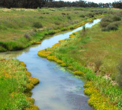
The Bucyrus dragline excavators which built the Mulwala Canal also built the Box Creek stormwater escape system during the late 1950s. Three natural flood runners ~ the Box Creek, Union Creek and Baratta Creek ~ were connected together to more effectively drain stormwater and provide a safety valve for flows in the Mulwala Canal. Box Creek originated on the northern side of the Mulwala Canal at Blighty. In 1992 the Box Creek Drainage Channel was built, draining land on the southern side of the Mulwala Canal between Finley and Blighty. This drainage channel goes under the Mulwala Canal to connect to the Box Creek at Blighty. The total length of the Box Creek system ~ drainage channel and creeks ~ is 130kms. Photo: MIL Collection. |
|
| sitemap • credits
& references • copyright • local
history links • contact & contribute • VISITORS |
||

